Naples and volcanoes: living on Europe's most dangerous geological landscape
Is Naples built on an active volcano?
Yes — Naples sits between two active volcanic systems. Mount Vesuvius, 12 km to the southeast, is a stratovolcano that last erupted in 1944 and remains classified active. The Campi Flegrei (Phlegraean Fields) volcanic field extends under and west of the city itself, with ongoing bradyseism (ground deformation) and hundreds of small earthquakes annually. Three million people live in the zone of risk.
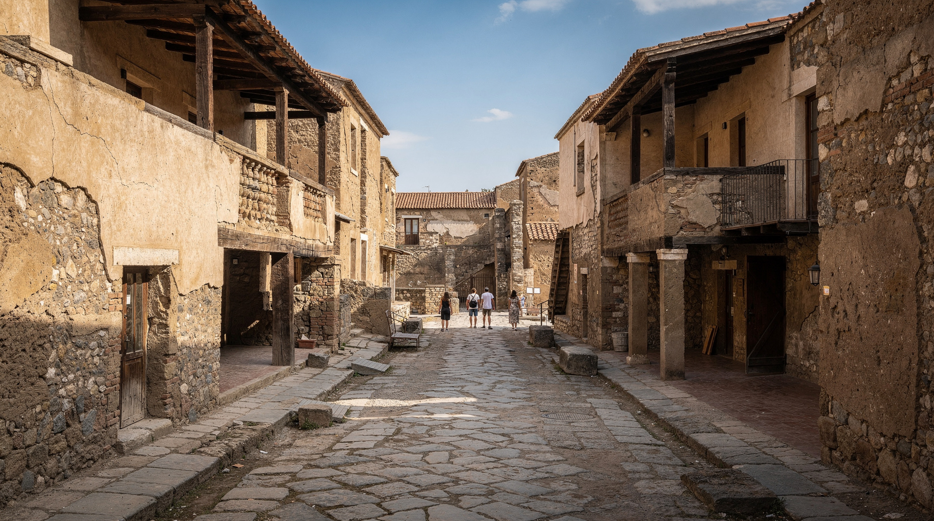
Naples is built in one of the most geologically active zones in Europe. The city itself sits on volcanic rock — the tufa that forms the walls of its oldest buildings and the tunnels of Napoli Sotterranea is the product of volcanic activity. Mount Vesuvius, visible from almost every high point in the city, destroyed Pompeii and Herculaneum in 79 AD and erupted last in 1944. The Campi Flegrei — a volcanic field beneath and around the city — is responsible for ongoing ground movement, hundreds of small earthquakes per year, and several very visible geothermal features west of Naples.
Approximately three million people live in the zone of elevated volcanic risk around Naples. This is not ignorance or indifference — it is the oldest calculation in the relationship between human settlement and geological hazard: the land is extraordinarily fertile, the climate excellent, the sea productive, and the geographic position commercially essential. The volcano is part of the terms of occupation.
| Where | Vesuvius (SE of Naples) and Campi Flegrei (W of Naples, under Pozzuoli) |
| Alert levels (2026) | Vesuvius: Base (green); Campi Flegrei: Yellow (heightened monitoring) |
| Visitor risk | None under current conditions — both systems are continuously monitored |
| Best way to engage | Vesuvius crater hike, or a Campi Flegrei day trip to Pozzuoli and Solfatara |
| Time needed | Half-day to full day per site |
Vesuvius: the known quantity
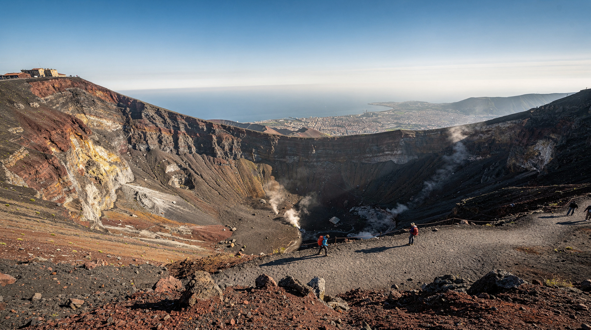
Mount Vesuvius is a stratovolcano — a cone-shaped volcano built from layers of hardened lava and ash from successive eruptions. It rises to 1,281 metres above sea level, visible from central Naples as the most distinctive topographical feature on the eastern horizon. The mountain is part of a complex system: the older caldera of Monte Somma partly encircles Vesuvius to the north, the product of an earlier and larger eruption than 79 AD.
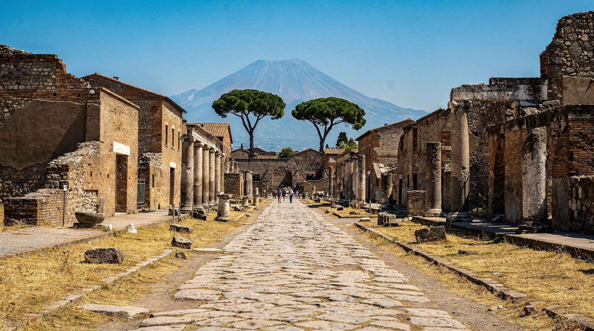
The 79 AD eruption. The eruption that destroyed Pompeii and Herculaneum began in the late morning of 24 August (or possibly 24 October — recent research suggests the autumn date) 79 AD. The sequence involved an initial explosive column of volcanic material that reached approximately 32 km altitude, rained pumice and ash onto the surrounding area for several hours, and then collapsed repeatedly to produce pyroclastic flows (fast-moving avalanches of hot gas and rock) that devastated the landscape within about 15 km of the summit.
Pompeii was covered by approximately 4–6 metres of tephra (loose volcanic material). Herculaneum was hit by more direct pyroclastic flows and buried deeper and faster. The death toll is estimated at 2,000 people at Pompeii alone; the regional total was likely much higher. Estimates for the total death toll range from 16,000 to considerably more.
The eruption also reshaped the physical landscape: the coastline changed, rivers changed course, and the fertile agricultural land around the bay was covered in volcanic debris. Within a generation, agricultural activity had resumed — the same volcanic material that killed people made the soil exceptionally productive for vine cultivation. The Lacryma Christi wines from the Vesuvius slopes today are a direct continuation of the agricultural tradition that Roman farmers began again after 79 AD.
Later eruptions. Vesuvius has erupted approximately 50 times since 79 AD. Major historical eruptions include 472 AD (which sent ash as far as Constantinople), 1631 (which killed approximately 3,000–6,000 people and reshaped the volcano’s summit), and a series of eruptions in the 18th and 19th centuries that the Bourbon court and their archaeologists observed with great scientific interest — the early history of vulcanology as a discipline was written partly by researchers watching Vesuvius.
The 1944 eruption was the most recent. Lava flows from the 19–29 March eruption destroyed the towns of San Sebastiano al Vesuvio and Massa di Somma, damaged Allied airfields at Terzigno, and killed approximately 26–27 people. Since 1944, no eruption has occurred. The current alert level is Base (green) — the lowest level on the Italian civil protection scale.
Current monitoring. The Osservatorio Vesuviano, based in Naples, maintains continuous seismic, geochemical, and ground deformation monitoring of Vesuvius. The observatory’s data is publicly available. Any significant change in activity level would trigger escalating alert protocols (from Base through Yellow, Orange, to Red) and, at Orange level, would trigger partial evacuation of the zones closest to the volcano.
What a future eruption might look like. Scientists’ models suggest a subplinian or plinian eruption similar to 79 AD remains plausible, though current geological evidence suggests the magma chamber beneath Vesuvius is substantially less pressurised than in 79 AD. A smaller effusive eruption (lava flows rather than explosive column) is considered more likely in the near term. The Italian government’s evacuation plan (Piano Nazionale di Protezione Civile per il Rischio Vesuvio) designates a Red Zone of approximately 18 municipalities that would be evacuated before any eruption began.
The Campi Flegrei: the less-known threat
The Campi Flegrei (Phlegraean Fields — from the Greek phlox, fire) is a volcanic caldera system that extends from the western outskirts of Naples to the coastal towns of Pozzuoli, Baia, Bacoli, and beyond. Unlike Vesuvius, the Campi Flegrei does not have a single visible cone — it is a caldera system, the product of two major caldera-forming eruptions (the Campanian Ignimbrite, approximately 39,000 years ago, and the Neapolitan Yellow Tuff, approximately 15,000 years ago) that left a broad depressed landscape with hundreds of smaller volcanic features within it.
The visible evidence of volcanic activity within the Campi Flegrei is everywhere in the landscape:
Solfatara crater (Pozzuoli): An active volcanic crater visible to visitors — a wide, flat-bottomed depression with fumaroles (steam and sulphur vents), mud pools, and strongly sulphurous smell. The Solfatara is part of the Parco Regionale dei Campi Flegrei; access was restricted after a fatal accident in 2017 and has been partially restored. Check current access before visiting.
Bradyseism at Pozzuoli: The ground in and around Pozzuoli has risen and fallen by several metres over historical time — the columns of the Serapeum market building show marine boring marks at heights of up to 3.5 metres above their current base, evidence of periods when the land subsided and the sea covered the site. Recent years (2018–2025) have seen accelerating ground uplift (about 1 metre of uplift in the Pozzuoli area since 2012), accompanied by increased seismic activity. The current alert level for Campi Flegrei is Yellow (heightened monitoring), upgraded from Base in 2012.
The Lucrine Lake and Averno: Lake Averno, a circular volcanic crater lake west of Pozzuoli, was identified by Roman writers as the entrance to the underworld (Virgil set it as the gateway to Hades in the Aeneid). The Roman general Agrippa connected it to the Lucrine Lake and the sea via channels to create a naval base (Portus Iulius) in 37 BC.
A guided walking tour of the Solfatara and the wider Campi Flegrei area gives context that is hard to piece together independently — what you’re looking at geologically, and how the Roman sites at Baia and Cuma relate to the active volcanic ground beneath them.
Campi Flegrei and Pozzuoli guided walking tourThe tufa city: volcanic building material
The tuff (tufa) stone that built Naples is directly volcanic in origin — compressed layers of ash and pumice from Campi Flegrei eruptions, solidified into building stone. Neapolitan yellow tufa (tufo giallo napoletano) is specifically the product of the Neapolitan Yellow Tuff eruption 15,000 years ago. Its properties — relatively soft to quarry but structurally reliable once exposed to air — made it the ideal building material for Greek colonists arriving in a landscape without other good stone.
The Napoli Sotterranea cisterns and the Fontanelle cemetery cavern are both carved directly into this tufa. The Rione Sanità stands on and is partly carved into a tufa hillside. Walking through Naples’ underground is, in a literal sense, walking through the solidified product of prehistoric volcanic eruptions.
The fertile land and the wine
The volcanic geology that makes Naples dangerous is also what makes the surrounding agricultural land some of the most productive in Italy. The volcanic soils of the Vesuvian flanks, rich in minerals from millennia of eruptions, produce wines of notable character — the Lacryma Christi wines from the Vesuvius slopes and the Aglianico and Falanghina of the broader Campanian wine tradition are products of this specific volcanic terroir.
The tomato cultivation that is central to Neapolitan cuisine is also partly a story of volcanic soil. The San Marzano tomato, grown in the valley between Vesuvius and the Monti Picentini, is internationally regarded as a distinct variety of particular quality — its characteristics attributed in part to the mineral content of the volcanic alluvial soil.
How to engage with the volcanic landscape as a visitor
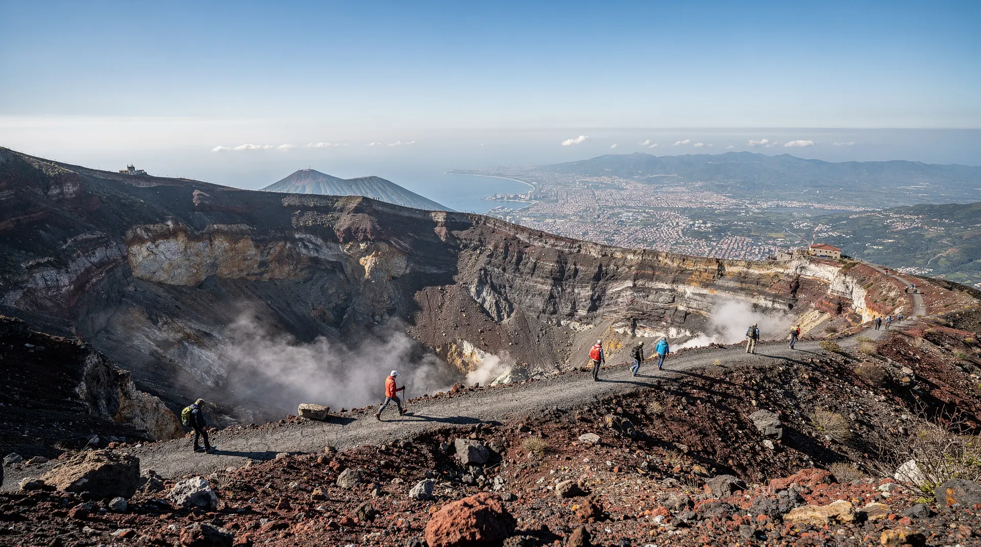
Hike the Vesuvius crater: The most direct engagement with Naples’ volcanic reality. The summit car park is at about 1,000 metres; the hike to the crater rim is 30–45 minutes on a maintained gravel path. Standing at the crater edge of an active stratovolcano that destroyed two Roman cities is genuinely impressive. See the hiking Vesuvius crater guide for logistics.
Visit Pompeii and Herculaneum: The human dimension of volcanic risk — what actually happened to real people in real buildings on 24 August 79 AD — is most clearly understood at the excavated sites. Pompeii is larger and more famous; Herculaneum is smaller, better preserved, and arguably more comprehensible. Both are within 30 minutes of Naples by Circumvesuviana train.
Campi Flegrei day trip: Pozzuoli’s Solfatara, the Rione Terra (ancient Roman city of Puteoli), and the coastal landscape of Baia can be explored in a day from Naples. The combination of active volcanic features, Roman archaeological sites, and the eerie bradyseism landscape makes this one of the more distinctive day trips from the city. See Campi Flegrei day trip.
MANN museum geological section: The National Archaeological Museum contains material from Pompeii and Herculaneum that contextualises the 79 AD eruption — the victims’ casts, the household objects frozen in time — within the broader history of the volcanic landscape.
A combined Pompeii and Vesuvius day is the most efficient way to see the human and geological sides of the same story in a single outing:
Full-day Pompeii and Vesuvius combo from NaplesVolcanic risk: how Naples plans for it
Understanding the practical side of volcanic risk helps put the visitor experience in context. The Italian civil protection system maintains a detailed evacuation plan for the area closest to Vesuvius (the so-called Red Zone, covering approximately 18 municipalities), with a target evacuation window built around the expectation that any major escalation would be preceded by days to weeks of detectable seismic and ground-deformation activity, not a sudden unannounced eruption.
Regular evacuation drills and public information campaigns are part of the ongoing civil protection effort, alongside the continuous monitoring from the Osservatorio Vesuviano. For Campi Flegrei, monitoring is arguably even more intensive given the population density directly above the caldera, and the current Yellow Alert reflects that heightened attention rather than any specific near-term forecast.
None of this changes the calculus for a visitor: the systems that would provide warning of a genuine escalation are the same systems that currently show both volcanoes at routine monitoring levels, which is why daily life, tourism, and the archaeological sites all continue to operate normally.
Frequently asked questions about Naples and volcanoes
Should I be worried about visiting Naples because of the volcanoes?
No. Current volcanic activity at both Vesuvius and Campi Flegrei is monitored continuously and any significant escalation in risk would be publicly communicated well in advance. The current alert levels indicate careful monitoring, not imminent eruption. The volcanic risk in Naples is a long-term reality, not an immediate visitor concern.
What is the Campi Flegrei Yellow Alert?
The Yellow Alert (Livello di Allerta Giallo) was established in 2012 in response to accelerating ground uplift and increased seismic activity in the Campi Flegrei area. It means that monitoring is intensified and civil protection protocols are on heightened readiness. It does not mean an eruption is expected. The Yellow Alert has been maintained since 2012 and is part of the ongoing volcanic monitoring framework, not an emergency declaration.
Can a Vesuvius eruption be predicted?
Volcanic eruptions cannot be predicted with precision, but they can be anticipated well enough for evacuation if monitoring is continuous. The Osservatorio Vesuviano and the Italian civil protection system have detailed protocols that trigger progressive alert levels based on seismic activity, ground deformation, and gas emissions. The Italian government’s official position is that adequate warning time would exist for evacuation before any major Vesuvius eruption.
Is Pompeii’s fate a realistic model for what Naples faces?
Partially. The 79 AD eruption was large (Volcanic Explosivity Index 5 — roughly “Plinian” scale). If a comparable eruption occurred today, the immediate impact on the Red Zone (closest communities) would be catastrophic. However: early warning systems, continuous monitoring, and a pre-established evacuation plan are all significantly more developed than anything available in 79 AD. The 79 AD population also had no knowledge that Vesuvius was a volcano — no major eruption had occurred in recorded human memory in that area. Modern residents know what they are living near.
How does the volcanic geology relate to the Naples food culture?
Directly. The volcanic soils produce the specific mineral profiles that give Campanian wine (Aglianico del Taburno, Lacryma Christi, Falanghina del Sannio), the San Marzano tomato, and the bufala mozzarella (the particular richness of Campanian buffalo milk is partly a product of the volcanic pastures) their distinctive characteristics. Naples’ food culture is inseparable from the volcanic landscape that produces its primary ingredients.